![](/images/other/stat-length.png)
![Randonnée Marche La Bastide - COL PALOMERE la PINOUSE - Photo](https://media.geolcdn.com/t/1900/400/ext.pjpeg?maxdim=2&url=https%3A%2F%2Fstatic1.geolcdn.com%2Fsiteimages%2Fupload%2Ffiles%2F1553511878bg_sport_marche.png)
COL PALOMERE la PINOUSE
MarcOBRECHT
Utilisateur
![Longueur](/images/other/stat-length.png)
![Altitude max](https://static1.geolcdn.com/siteimages/upload/files/1508320355ic_sort_altitude_max_24dp.png)
![Dénivelé positif](https://static1.geolcdn.com/siteimages/upload/files/1508320355ic_sort_den_pos_24dp.png)
![Km-Effort](/images/other/stat-length.png)
![Altitude min](https://static1.geolcdn.com/siteimages/upload/files/1508320355ic_sort_altitude_min_24dp.png)
![Dénivelé négatif](https://static1.geolcdn.com/siteimages/upload/files/1508320355ic_sort_den_neg_24dp.png)
![Boucle](https://static1.geolcdn.com/siteimages/upload/files/16400158638029165_repeat_loop_refresh_sync_direction_icon.png)
![Marche](https://static1.geolcdn.com/sitytour/trail-icons/101.png)
4h43
Difficulté : Moyen
![Scannez ce code QR pour ouvrir la randonnée dans l'application SityTrail](https://capi.geolives.com/qq0zvz2zws4bq2lad0pu/sitytour/trails/3967191/qr.png?size=200)
Application GPS de randonnée GRATUITE
À propos
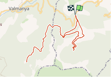
Randonnée Marche de 13,2 km à découvrir à Occitanie, Pyrénées-Orientales, La Bastide. Cette randonnée est proposée par MarcOBRECHT.
Description
Du col, monter par la piste en béton.
Arrivé sur ancienne voie chemin de fer, suivre voie . 100 m avant tunnel prendre à gauche et suivre balisage.
Au retour, même chemin mais, au lieu de descendre par la piste en béton, continuer par voie chemin de fer. A la barrière descendre par piste à Gauche
Localisation
Commentaires
Randonnées à proximité
![Randonnée A pied Valmanya - Tour del Canigó - Photo](https://media.geolcdn.com/t/375/260/d70f77f9-d4e3-4a97-8f21-2b252e3f9842.jpeg&format=jpg&maxdim=2)
![A pied A pied](https://static1.geolcdn.com/sitytour/trail-icons/100.png)
A pied
![](/images/other/stat-length.png)
![](https://static1.geolcdn.com/siteimages/upload/files/16400158638029165_repeat_loop_refresh_sync_direction_icon.png)
![Randonnée Marche Corsavy - Tour du Canigou - Photo](https://media.geolcdn.com/t/375/260/ext.jpg?maxdim=2&url=https%3A%2F%2Fstatic1.geolcdn.com%2Fsiteimages%2Fupload%2Ffiles%2F1553511878bg_sport_marche.png)
![Marche Marche](https://static1.geolcdn.com/sitytour/trail-icons/101.png)
Marche
![](/images/other/stat-length.png)
![](https://static1.geolcdn.com/siteimages/upload/files/16400158638029165_repeat_loop_refresh_sync_direction_icon.png)
![Randonnée Marche Prunet-et-Belpuig - BOULE d'AMONT - La TRINITE - Photo](https://media.geolcdn.com/t/375/260/63148342-eaf9-42f9-af5b-21ab9e845710.jpg&format=jpg&maxdim=2)
![Marche Marche](https://static1.geolcdn.com/sitytour/trail-icons/101.png)
Marche
![](/images/other/stat-length.png)
![](https://static1.geolcdn.com/siteimages/upload/files/16400158638029165_repeat_loop_refresh_sync_direction_icon.png)
![Randonnée sport Valmanya - 20241013 Los Masos-Prat Cabrera… - Photo](https://media.geolcdn.com/t/375/260/31e31d29-0e6a-46e9-9786-fccc3cfba894.jpg&format=jpg&maxdim=2)
sport
![](/images/other/stat-length.png)
![](https://static1.geolcdn.com/siteimages/upload/files/16400158638029165_repeat_loop_refresh_sync_direction_icon.png)
![Randonnée Marche Prunet-et-Belpuig - Boule d’amont /Chapelle de la Trinité / Prunet - Photo](https://media.geolcdn.com/t/375/260/68eed7a9-ae13-40d7-8c91-a7b1707b93bf.jpg&format=jpg&maxdim=2)
![Marche Marche](https://static1.geolcdn.com/sitytour/trail-icons/101.png)
Marche
![](/images/other/stat-length.png)
![](https://static1.geolcdn.com/siteimages/upload/files/16400158638029165_repeat_loop_refresh_sync_direction_icon.png)
![Randonnée Marche Baillestavy - 20221127 Baillestavy- Valmanya - - Prat Mitja - Photo](https://media.geolcdn.com/t/375/260/72e21f75-cd75-4254-89f0-c0a060a5d8d3.jpg&format=jpg&maxdim=2)
![Marche Marche](https://static1.geolcdn.com/sitytour/trail-icons/101.png)
Marche
![](/images/other/stat-length.png)
![](https://static1.geolcdn.com/siteimages/upload/files/16400158638029165_repeat_loop_refresh_sync_direction_icon.png)
![Randonnée Marche Corsavy - 2022 TRANSPYRÉNÉENNE : refuge de Batere -Montalba - HOSTAL dels Traucayres - Photo](https://media.geolcdn.com/t/375/260/2dc3b86f-78ad-496e-bb51-5b658d77182b.jpg&format=jpg&maxdim=2)
![Marche Marche](https://static1.geolcdn.com/sitytour/trail-icons/101.png)
Marche
![](/images/other/stat-length.png)
![](https://static1.geolcdn.com/siteimages/upload/files/16400158638029165_repeat_loop_refresh_sync_direction_icon.png)
![Randonnée Marche Baillestavy - 20220519 Ballestavy - Photo](https://media.geolcdn.com/t/375/260/4d0efe9c-9bcb-43a8-b0f2-554388676ee1.jpg&format=jpg&maxdim=2)
![Marche Marche](https://static1.geolcdn.com/sitytour/trail-icons/101.png)
Marche
![](/images/other/stat-length.png)
![](https://static1.geolcdn.com/siteimages/upload/files/16400158638029165_repeat_loop_refresh_sync_direction_icon.png)
![Randonnée Marche Valmanya - Los Masos Prat Cabrera - Photo](https://media.geolcdn.com/t/375/260/5a982ed8-e8a5-434c-a713-d69b9e6ce2c7.jpg&format=jpg&maxdim=2)
![Marche Marche](https://static1.geolcdn.com/sitytour/trail-icons/101.png)
Marche
![](/images/other/stat-length.png)
![](https://static1.geolcdn.com/siteimages/upload/files/16400158638029165_repeat_loop_refresh_sync_direction_icon.png)